
SVAMITVA Scheme 2026: Overview
SVAMITVA — Survey of Villages Abadi and Mapping with Improvised Technology in Village Areas — is a flagship central sector scheme launched in 2020 by the Ministry of Panchayati Raj. The scheme addresses a centuries-old problem: the lack of formal ownership documents for residential properties in rural inhabited (Abadi) areas.
Before SVAMITVA, rural families had no legal proof of ownership for their homes and land. Banks refused loans without documentation. Property disputes were rampant. The SVAMITVA scheme changes this by using survey-grade drones to create accurate digital maps of every rural household, issuing a legally recognized Property Card (Record of Rights) to each owner.
In 2026, SVAMITVA stands as one of the world's largest drone-based land mapping initiatives. The scheme was showcased at the Republic Day Parade 2026, winning the Best Innovation Award, and was highlighted at the World Bank meeting in May 2026 as a model for developing nations.
SVAMITVA Progress 2026: Key Statistics
| Metric | Value (as of May 2026) |
|---|---|
| Drone Survey Completed Villages | 3,27,258 (95%+ of 3.44 lakh target) |
| Property Cards Prepared | 3.10 Crore+ |
| Maps Handed Over to States | 2.88 Lakh Villages |
| Parcels Mapped | 11.22 Crore+ |
| Bhu-Aadhaar Numbers Issued | 23 Crore+ |
| States/UTs On-boarded | 31 |
| Rural Land Value Unlocked | Rs 135 Lakh Crore (study by IIM Ahmedabad) |
| Loan Amount Increase After SVAMITVA | 23% (EAC-PM study, April 2026) |
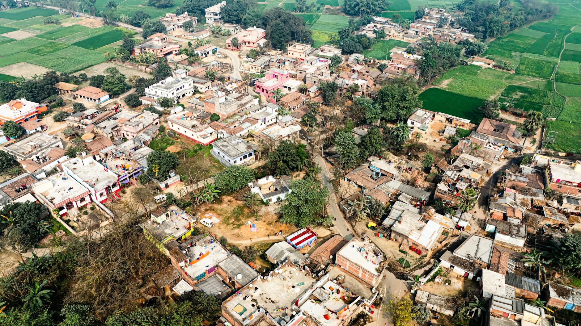
How the SVAMITVA Drone Survey Works
The SVAMITVA mapping process follows a carefully designed 5-step workflow:
Step 1 — Chuuna Markan (Lime Demarcation): Village property owners mark their boundaries with white lime powder. This is a community event overseen by the Gram Panchayat. The 2026 guidelines recommend using GPS tags during this phase to prevent neighbor disputes. All residents are notified in advance through Gram Sabha meetings.
Step 2 — CORS Network Setup: Survey of India establishes Continuously Operating Reference Stations (CORS) in the region. The CORS network provides real-time GNSS corrections with ≤5 cm horizontal accuracy in X, Y, Z coordinates. As of 2026, this network has reached nationwide coverage, ensuring that every drone survey references the same high-precision coordinate system.
Step 3 — Drone Flight and Aerial Survey: Survey-grade drones equipped with high-resolution cameras and multispectral sensors fly over the village at designated altitudes. Each drone carries RTK (Real-Time Kinematic) modules that connect to the CORS network for cm-level positioning. The drones capture overlapping imagery (frontlap 70%, sidelap 60%) that is later processed into orthorectified maps and 3D models.
Step 4 — Photogrammetric Processing: The captured drone imagery is processed using photogrammetry software to create:
- Orthophoto maps (true-to-scale aerial images)
- Digital Surface Models (DSM) with elevation data
- Cadastral maps showing individual property boundaries
- 3D village models for Gram Manchitra portal
Step 5 — Property Card Generation: After ground verification and Gram Sabha approval, digital Property Cards are generated. These cards contain:
- Unique 14-digit Bhu-Aadhaar ID
- Owner's name, father's name, and photograph
- Property boundaries with GPS coordinates
- Plot area in square meters
- Survey number and khata details
- QR code for digital verification
The entire process, from drone flight to Property Card distribution, takes approximately 3-6 months per village. Daily, over 500 villages are surveyed by drone teams across India.
SVAMITVA Property Card: How to Download Online
Method 1 — SVAMITVA Portal (svamitva.nic.in):
- Visit svamitva.nic.in
- Click on "Property Card" or "Search Property Card"
- Select your State, District, Tehsil/Block, and Village
- Enter your Holding Number or Property Card ID
- View and download your Property Card as PDF
Method 2 — DigiLocker:
- Open DigiLocker app or visit digitallocker.gov.in
- Search for "SVAMITVA Property Card"
- Enter your Aadhaar number
- The card is automatically linked and available for download
- Any time you need the card, just log in to DigiLocker
Method 3 — State-Specific Portals: Several states have their own SVAMITVA portals:
- Uttar Pradesh: svamitva.up.gov.in
- Gujarat: svamitva.gujarat.gov.in
- Andhra Pradesh: svamitva.apcfss.in
- Haryana: 112.196.37.108/swamitva/
Cards are also available at your local Gram Panchayat office. The Gram Panchayat Secretary can issue a printed copy of your Property Card.
SVAMITVA Benefits: Financial and Social Impact
Bank Loans as Collateral: The biggest impact of SVAMITVA has been financial inclusion. Rural families can now use their Property Card as collateral for loans from banks including SBI, PNB, ICICI, and regional rural banks. A study by the EAC-PM (Economic Advisory Council to the Prime Minister) published in April 2026 found that loan amounts for rural households increased by 23% after receiving SVAMITVA cards. Major banks have launched specialized "SVAMITVA Loan" products for home improvement, business, and education.
Property Dispute Reduction: With GPS-tagged boundaries and legal ownership records, property disputes in rural areas have reduced significantly. Haryana and Uttar Pradesh reported a 40% reduction in land-related court cases after SVAMITVA implementation. The clear digital records leave no room for boundary ambiguity.
Rs 135 Lakh Crore in Unlocked Value: A study by IIM Ahmedabad, showcased at the World Bank meeting in May 2026, estimated that SVAMITVA has unlocked Rs 135 lakh crore in rural land value. Properties that were previously considered "unbankable" now have recognized market value. This has spurred rural construction, small businesses, and local economies.
Integration with Government Schemes: SVAMITVA Property Cards are now integrated with:
- PMAY 2.0 (housing) — property card serves as address proof
- PM Surya Ghar — rooftop solar eligibility verified via drone map
- Jal Jeevan Mission — pipeline routing using Gram Manchitra maps
- PM-KISAN — address verification for income support
- SVAMITVA cards are also used for property tax assessment by Gram Panchayats
Gram Manchitra: 3D Village Planning Portal
Gram Manchitra (grammanchitra.gov.in) is a spatial planning portal that leverages SVAMITVA data for Gram Panchayat Development Plan (GPDP) preparation. Villagers and panchayat officials can view their village in 3D, identify plot boundaries, plan infrastructure projects, and visualize development outcomes before implementation.
The portal has been used for planning Jal Jeevan Mission water pipeline routes, identifying locations for schools, Anganwadi centers, and health sub-centers under PM-POSHAN and Ayushman Bharat, and mapping road connectivity for PM Gram Sadak Yojana. In 2026, the Ministry of Panchayati Raj showcased Gram Manchitra at a UN climate action event, demonstrating how high-resolution spatial data supports disaster risk reduction and rural planning.
SVAMITVA 2026: State-Wise Progress
As of May 2026, 31 states and union territories have on-boarded the scheme. The leading states include:
- Haryana: First state to achieve 100% drone survey. All villages mapped, cards distributed.
- Uttar Pradesh: Largest number of villages surveyed — over 95,000 villages completed.
- Madhya Pradesh: Rapid progress with over 50,000 villages mapped.
- Rajasthan: Over 40,000 villages surveyed with extensive card distribution.
- Andhra Pradesh: Target of 1 crore property cards by March 2026 (The Hindu, Sep 2025).
- Gujarat: State-specific portal active with extensive coverage.
- Himachal Pradesh: 13,920 villages covered via drone survey (Times of India, Dec 2025).
Eight states have achieved saturation in Property Card distribution — meaning every eligible rural household in those states has received their card. The remaining states are in various stages of drone survey, map processing, and card distribution.
Challenges and Limitations
Despite its success, SVAMITVA faces several challenges in 2026:
Red Zone Restrictions: Drone surveys in border areas and "red zones" (areas with security restrictions) require special clearance from the Ministry of Home Affairs and the Ministry of Defence. Karnataka's Dakshina Kannada district, for example, stopped drone survey after covering only 19.19% of villages due to red zone restrictions (The Hindu, Feb 2026).
Dispute Resolution: While SVAMITVA has reduced overall disputes, existing boundary disputes between neighbors can delay card issuance in some villages. The Gram Sabha plays a crucial role in resolving these before final map approval.
Data Privacy Concerns: With millions of property records and GPS coordinates stored digitally, questions about data security and privacy have arisen. The government has implemented encrypted storage and access controls on the svamitva.nic.in portal.
Scale of Target: The scheme targets 6.62 lakh villages over the next 4 years — nearly double the current coverage. This requires scaling up drone teams, CORS infrastructure, and processing capacity.
Future Roadmap
The SVAMITVA scheme has an ambitious roadmap beyond 2026:
- Complete drone survey of all 6.62 lakh villages over next 4 years
- Integration with National Generic Document Registration System (NGDRS) for property transactions
- Real-time property mutation updates through Gram Panchayats
- AI-based change detection using satellite imagery to automatically update property records
- Expansion of CORS network to cover every block in India
- Integration with PM Kisan, PMAY, and other DBT schemes for automatic beneficiary verification
Last Updated: May 31, 2026 | Source: Ministry of Panchayati Raj (Official Website)